Reptilian Initiation in Sabino Canyon
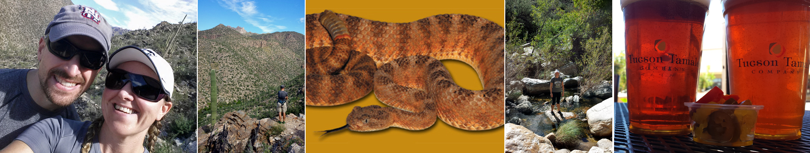
Exploring Sabino Canyon and all its friendly inhabitants back in November, a full day capped off with tamales and beer to celebrate not getting bitten by a rattlesnake. Snake photo from AZ Game and Fish Department website; we didn’t stick around long enough to take one of our own.
Everyone we’ve encountered in Tucson has mentioned Sabino Canyon as a “must go” destination. By everyone, I mean our realtor, bartenders, hair stylists, neighbors, coworkers and pretty much anyone else who learns we just moved here. So on our first plan-free Saturday in town, back in November while I was visiting for the weekend, we headed up to Sabino Canyon to check it out for ourselves. (more…)
Geeks and Freaks in Saguaro National Park
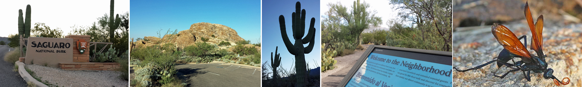
Scenes from Saguaro (L to R): Saguaro East entrance, Javelina Rocks, Saguaro cacti, “welcome” signage on nature trail and close-up of a tarantula hawk (photo source: desertusa.com)
Our unofficial summer hiatus is over, and we’re getting back on the blog train from our new home in Tucson. (Well, actually, I’m writing in this post while in Provo, Utah, where we’ve been all week. M’s on a business trip here, and I’m taking the opportunity to explore and write…two of my favorite activities! More about Provo later.) We’d been splitting time between Arizona and New Hampshire for more than two months by the time we finally made our move official the day after Thanksgiving. Our trusty companion, Sal, arrived via car carrier the next day, and we promptly swept him off on a series of local adventures. (more…)
Exploring Acadia National Park from the Acacia House Inn
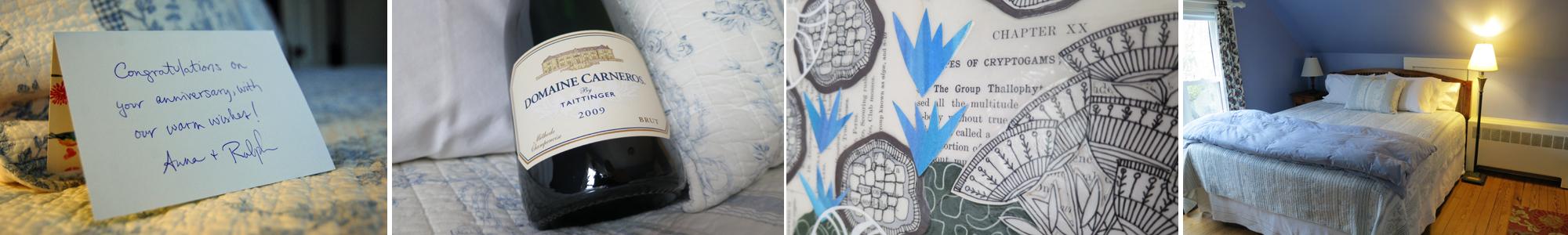
Room 5 at the Acacia House Inn, our third-floor, anniversary hideaway in Bar Harbor, Maine.
A few years ago, on a very lucky Friday the 13th, we eloped to Maine, specifically to Northeast Harbor, a tiny village at the mouth of Somes Sound, where the ladies in the Town Clerk’s office were giddy and gracious in hosting an impromptu wedding for us on just a few days’ notice. They served as officiant, witnesses, photographer, and florist, presenting me with a bouquet of fresh-cut daffodils from outside the building. We spent the rest of the weekend exploring the island by bike and foot. When we arrived back home, we sent the Town Hall crew a thank you note with Portsmouth chocolates and our favorite picture from that day. And so began our May tradition of adventuring on Mount Desert Island.
This weekend, we arrived on Friday for four days of hiking, running, writing, sleeping, and eating. Acadia National Park is the frequent site of the first three activities, while the Acacia House Inn is our preferred site for the last two. We’ve written extensively about our national park adventures at Acadia, but we’ve been remiss in writing about our favorite B&B, the place we stayed that first spring and almost every year since. Let’s correct that right now! (more…)
Back to the Alternative Grind
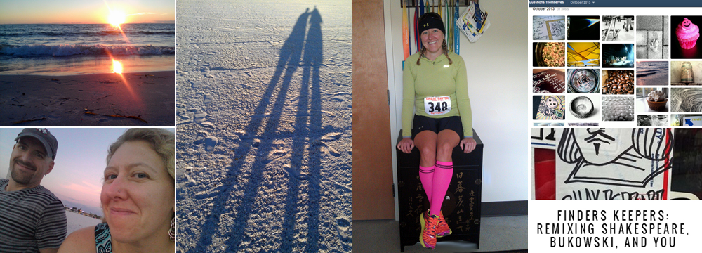
L to R: Three sunset scenes from Florida; 5K racing on my birthday; my October photo project archive; and M’s new poetry blog
We realized today that we haven’t posted an update in close to two months. How does that saying go? Time flies when you’re exhausted, confused, and energized by new ideas? We arrived home from Germany at the end of September, having traveled for 12 of the 15 preceding weeks. Six weeks spent road tripping across the Canadian and American west followed by six weeks in Europe, with three weeks at home in between to do laundry, repack, and taper for the marathon. By the time we finally returned to our cozy apartment in New Hampshire eight weeks ago, we were jet-lagged, burned out, and ready to slow down. And we were supposed to leave in six days for our next adventure: two weeks of national park hopping in the Pacific Northwest. (more…)
We’re Off on the Road to Achill Island
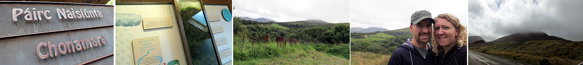
Scenes from our stop at Connemara National Park
We left Clifden Thursday morning with our sights set on tiny Achill Island on Ireland’s west coast. It was slated as a short drive (less than two hours), but we planned to take our time. Our first stop—just twenty minutes or so from the inn—was at Connemara National Park. On any other day, we would have trekked to the top of the park’s famous (and fog-covered) Diamond Hill. But two days before a marathon is not the time to take on an unknown hike (any hike, really). (more…)
A Change of Plans in Lake Louise
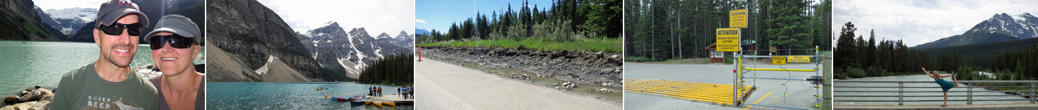
L to R: Late afternoon on the shore of Lake Louise; nearby Moraine Lake; a washed-out section of the Banff Legacy Trail; the electrified bear fence surrounding the campground; and post-run yoga overlooking the Bow River.
After leaving Jasper via the Icefields Parkway, our first stop in Banff National Park was the small settlement of Lake Louise, most famous for its ski area and storied Fairmont hotel. The hotel sits directly on the glacial lake, but the shore area and trails behind the hotel are open to the public. We headed to the lake the evening we arrived in an attempt to avoid tour bus crowds, and we were rewarded with a parking space close to the water. The lake was pretty, but the light wasn’t quite right, and the scene didn’t measure up to either of our expectations nor to other lakes we encountered. Moraine Lake in Jasper and Maligne Lake, just a few miles away from Lake Louise at the end of a windy mountain road, were arguably more picturesque…at least on the days we visited them.
We spent the night at the HI hostel in Lake Louise, conveniently located near the center of town. Actually, town is an overstatement. It’s more like a small tourist village within the national park, with one main intersection, a gas station, a few inns, several overpriced restaurants, and a gazillion tour buses. In short, nowhere we wanted to be. We went to bed early, much to the chagrin of the 20-something German guys with whom we shared our 4-person bunkroom. (more…)
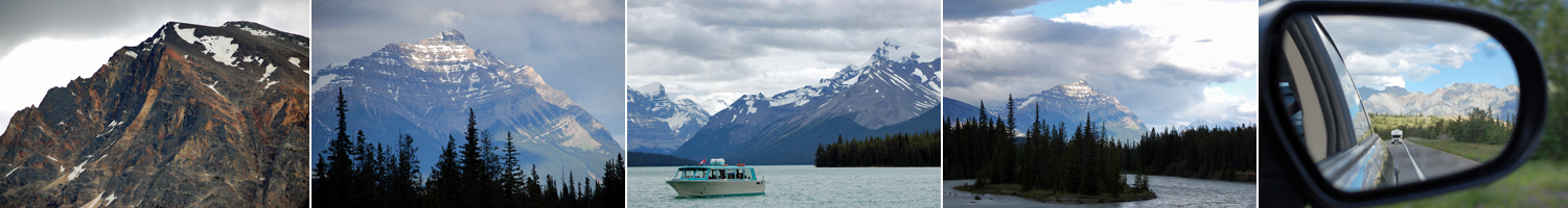
The Rest of Jasper: Athabasca, Icefields, and Wilcox
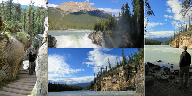
Scenes from the Athabasca River at Athabasca Falls, both above and below the 23-meter drop. While not exceptionally tall, the falls are some of the most powerful in the mountains due to the size of the river compared to the narrow canyon through which it flows.
Our visit to Jasper was the perfect start to our time in the Canadian Rockies. Jasper is a mellow little mountain town that quickly became one of the highlights of the trip. We weren’t thrilled to be leaving after just three days, but we were excited about what lay ahead: the Icefields Parkway and quaint towns within Banff National Park (Lake Louise, Banff, and Canmore). (more…)
Stranger Danger
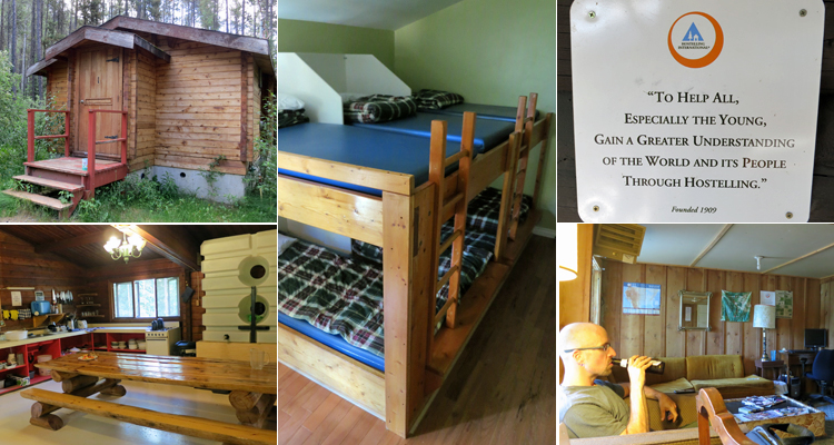
L to R/top to bottom: Our first wilderness cabin and rustic kitchen in Jasper N.P.; the offending 6-person bunk last night in Canmore; Hostelling International’s mission (They just need to add “up-close and personal”); and my mission tonight at Glacier N.P. (blogging and beer).
Prologue: I wrote this post last night while laying in the middle bunk of a six-person bunk bed (picture the middle seat on a plane…only for sleeping). As you can imagine, I wasn’t in the best of moods. As a result, the post is a bit of a rant, but it’s still mostly true. I’m writing this prologue from the common room of a rustic hostel in East Glacier, Montana, where the peeps are friendly, we have a private room, I’ve had two Montana beers and my perspective has “improved.” Nonetheless, I thought it fitting to share my honest hosteling experiences with you… (more…)
Jasper National Park (Put It On Your Bucket List)
Get your camera! (L to R): Random mountains at sunset and sunrise; scenic Lake Maligne; amazing scenery in every direction.
Greetings from Jasper National Park in Alberta, Canada…our first official national park of this trip! Jasper is the farthest northwest that we will venture this summer, and it is absolutely worth the 3,000+ miles we trekked across the continent to get here. Jasper is the largest of Canada’s Rocky Mountains parks, and it’s also less trafficked than Banff and Yoho to the south. We try to avoid clichés and hyperbole here on WPG, but truth is, since we arrived in Jasper, there has been a stunning, mind-blowing, awe-inspiring, picturesque cliché around every corner.
We’ve been here for less than 24 hours, but it feels more like a week. We’ve visited the Miette Hot Springs, sampled local brews, stayed overnight in a rustic wilderness hostel (no running water), ran four miles around town this morning (nearly running into an elk), and hiked a bit at Lake Maligne. We are now back in town jumping on the grid for a few minutes before returning to the hostel (with a planned visit to Athabasca Falls on the way). (more…)
On The Road Again
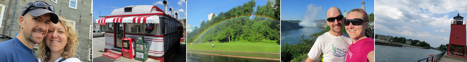
L to R: Outside our building on morning #1, small town NH diner, Niagara rainbow, running by the falls in ON, and exploring Charlevoix, MI
Greetings from Grand Forks! So much has happened in the last few days, making it hard to believe we’ve been on the road for less than a week. We’ve traveled more than 1,800 miles from home in New Hampshire to this university town on the Red River.
After setting out early last Wednesday morning, we were able to connect with friends from California (who happened to be in NH on vacation) and meet their adorable five-month-old son. We stayed in Niagara, ON Wednesday night and enjoyed a misty, rainbow-filled run along the falls in the morning before arriving Thursday afternoon at a friend’s house near Lansing. We spent a sunny few hours floating around the pool, catching up on the last year and enjoying good company.
We hit the road again Friday morning and meandered (more…)
The Countdown is On
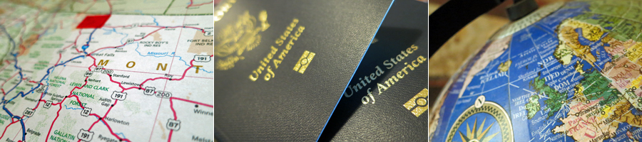
Tools of the trade (L to R): Old-school road tripping with an actual map; freshly-minted passports ready for the next 10 years of action; and a sneak preview of our fall travels.
Happy June, everyone! We hope those of you in New England are enjoying this early taste of summer. We’re staying cool indoors today, putting the finishing touches on our upcoming travel plans. For the past month or so, we’ve been busy mapping out three separate adventures in 2013: an old-fashioned road trip through the western U.S. and Canada, a European slow-cation, and a Pacific Northwest park-bagging loop.
All that trip planning has been in addition to the task of figuring out things like where we want to live for the next year and how we want to balance work and travel as we continue down this path of self-employment. For the most part, we’ve answered the big questions, and we can freely go forth into the universe for another round of aimful wandering.
So what’s ahead during WPG’s main travel season this year? (more…)
“…While We’re Fit Enough to Enjoy It”

L to R: Exploring the forts of Old San Juan, putting on a clinic in the ship’s bowling alley, hiking in the USVI National Park, and killing it with hover lunges and rows in TRX class.
We’ve talked about this time in our lives as one of self-assigned creative sabbatical. We’ve also referred to this year as one borrowed from retirement to travel while we are young enough—and fit enough and healthy enough—to enjoy it. This concept was evident during the last two weeks as we ventured to the Caribbean for a little pre-winter island hopping. I’ll share the how and the why behind the trip, along with other random musings, over the next few days. In the meantime, I’ve been meditating a bit on how the “fit enough” concept contributed to some of my best experiences on the cruise.
We knew we’d be consuming a little (okay, a lot…) more food and drink than we normally do, so we agreed in advance that we’d workout every day to keep any vacation weight gain in check. Admittedly, daily workouts aren’t much different from our routine at home, but it was important to remind ourselves of our priorities and to keep our ongoing fitness goals in the front of our minds even as we sailed south in search of rum and reggae. (more…)
Summertime in Central Michigan

L to R: Crossing back into the U.S. at Blue Water Bridge; Capitol Dome in Lansing; inside the Lansing City Market; and the MSU campus
Greetings from Michigan! Michigan is the 21st state we’ve traveled through this year, and we picked up our first Canadian province (Ontario) on the way. By the time this particular trip ends in early September, we’ll have touched ground in 26 states since March. (As for the license plate game, we’re still on the lookout for North Dakota and Wyoming, but we’re headed in the right direction…) I was hoping this would be the year I’d notch the last three states I need, but a lot has changed since we first envisioned this trip in the spring. (more…)
Disconnecting for a Few Days…
We’re going off the grid for a few days, camping and hiking in the woods of Acadia. We will update our Twitter feed (which you can see on the right side of this site) when we can, but we probably won’t do a long post again until this weekend when we roll back into New Hampshire for our friends’ wedding. Hope you all have a great week!
Milestones and a 20-Miler

It’s been a week of milestones: selling the house, hitting 50,000 miles with Sal the Subaru, and today, celebrating our anniversary. Last year, we snuck away to Bar Harbor to get married, and this year, we returned to town to celebrate the conclusion of a crazy first year while kicking off a new one. We’re staying in the same room at the same inn, one with delicious breakfasts and cozy beds, and we’re enjoying the relative calm of a resort town before the summer season begins. The weather has been perfect these past two days, and since we’re expecting rain later this week (while we’re camping, of course…), we’ve been playing outdoors every day. Today’s adventure was a 20-mile bike trek across two loops of the carriage roads we hadn’t done last year, plus one we had. We left from the Eagle Lake parking lot and headed north around the Witch Hole Pond loop. It was an easy, rolling start to the day, followed by a moderate climb to some fantastic island views. We then cruised back to the start of Aunt Betty Pond loop, a strenuous 6-mile section that managed to be uphill in both directions. After returning via the Eagle Lake loop, we were sitting at 18.3 miles, so we pushed our tired legs a bit more to reach the 20-mile mark. Along the way, I experimented a bit with video of our ride. Maybe someday I’ll graduate to a helmet cam, but for now, I’m using a handheld one, which can be a little bumpy (so don’t watch if you get dizzy easily…). The first clip was shot along a flat stretch and contains a brief narrative. The second one is a bit longer, with very little narrative, lots of wind and a bit of speed. I had the camera in my right hand, which is also my braking hand, so not my brightest move. Hopefully the video gives a little insight into what it feels like to fly down a gravel mountain at 20-miles per hour… -J
Don’t Look Down!

Insane cliff faces, rocky trails, and stunning vistas were the stars of today’s adventure
I’ve never been fond of heights. I remember refusing to sit anywhere but on the floor in the middle of our Ferris Wheel car in Niagara Falls at a young age. In 8th grade, I practically had a nervous breakdown on our class rock climbing trip when I stood roped and harnessed at the top of a 150-foot cliff and had to lean backwards over the edge to rappel down.
In my adult life, not much has changed between me and heights. When J and I rode the Ferris Wheel in Paris last summer, I was nervous (although I did sit in my assigned seat for the entire ride). When we stood at the top of the aptly named “Jump Off” in The Smokies two months ago, I couldn’t wait to continue our hike a bit further from the edge. Today, I pushed the limits of my fears and tackled some challenging trails in Acadia National Park.
The park has two “hiking” trails that are often referred to as “technical rock climbing without the ropes.” These trails are The Precipice (a 0.9 mile trail that basically scales the side of an 930-foot cliff) and The Beehive (a slightly smaller cliff at 0.6 miles and 520 feet). This time of year The Precipice is closed due to peregrine falcon nesting season (sweet!), but The Beehive is open. J was excited for the hike, and after watching several YouTube videos and online reviews (that didn’t help much), I reluctantly agreed to make the trip.
While we lingered over coffee at the B&B this morning, we looked at our pocket hiking guidebook (purchased for a mere $3.50 at our local coffee/used bookstore, Crackskulls) and planned a hike that would bring us up The Beehive, across two miles of ridgeline to the summit of Champlain Mountain, and down over Huguenot Head on a trail made up of nearly 1,500 pink granite steps (interpret that last word loosely…). At the bottom, we would trot a short three miles along the Park Loop Road to get back to our car. It all sounded amazing, but I needed to get past The Beehive to enjoy the rest.
“Just keep going and don’t look down,” was my mantra for the first hour of the day. Even near the bottom of The Beehive, we had to use iron rungs secured into the rocks to get from one ledge of the trail to the next. A little further up, we resorted to crawling over a series of iron bars laid out like a ladder across a 20-foot drop. The two most difficult spots included a double series of iron bars that brought us almost straight up a rocky patch about 300 feet into the climb and a corner that required the use of one iron rung to scoot around it while stepping over a gap in the cliff’s edge.
Despite feeling weak in the knees, we made it to the top along with several other climbers, including a group from Dallas on their second-ever hike. (Their first was Mt. Dorr…yesterday.) It’s true that many people journey up The Beehive each year without issue, but before we started out, I wasn’t sure that would be the case for us. By the end of the day, we not only conquered The Beehive (and my fear of heights), but we enjoyed the open ridgeline walk and 360-degree views of the Atlantic, Mt. Desert Island and downtown Bar Harbor from the summit of Champlain Mountain. It was totally worth the terror. -M
Test Driving Acadia’s Carriage Roads

Clockwise, from L: Jenn modeling a signpost; Marty rocking his ride; taking a break by Jordan Stream; Signpost 16; Jordan Pond and The Bubbles ridge; private gatehouse within park
After a five-week break to sort out things on the domestic front, we’re pleased to report that our National Park road trip is back on track! This week’s destination: Acadia National Park on Mt. Desert Island in Maine. We first visited the park last spring just for a weekend, and we’ve returned this year for an extended stay. We’ll spend four nights at a cozy B&B in downtown Bar Harbor and then an additional four nights at a campground within the park.
Acadia National Park was the first park established east of the Mississippi River. It is also notable for the fact that its designation as a park was spearheaded by local residents, many of whom (like George Dorr and the Rockefellers) were wealthy owners of summer homes on the island. Today, a handful of private residences are still scattered throughout the park, and sections of the famous carriage roads on private land abutting the park are off-limits to bicyclists. I’m not sure of the behind-the-scenes land politics, but as a casual visitor, it seems the public-private boundaries enjoy an easy coexistence.
We hadn’t been on our bikes in several months, so before heading out to tackle 20 or 30 (or more!) miles of road, we opted to start with a short 10-mile loop between Northeast Harbor and Jordan Pond. Although there are more than 40 miles of carriage roads to explore, it’s pretty hard to get lost. Roads are well-marked with numbered signposts that also include directional signage for popular park destinations like Jordan Pond House or Eagle Lake. The Park Service also provides a carriage road map that indicates mileage between signs.
Those of you who haven’t been to Acadia might share my initial romantic vision that carriage roads are pleasant and flat, probably made of packed dirt or maybe even paved. They are not. While they are indeed pleasant, they are the opposite of flat. They are groomed with crushed gravel (which can be loose and slippery under mountain bike tires) and they rise and fall repeatedly, climbing and descending hundreds of feet depending on the route you select.
Today’s route was a new stretch of trail for us, and the climb started immediately from the parking lot. Although our legs and lungs are well-conditioned from running, we were winded and weary at the top of some of today’s hills, quads burning. But the rewards were worth the effort. We enjoyed sunny skies, sweeping vista, secret streams, and of course…speeding downhill while grinning like kids, trying not to lose complete control of our bikes or eat facefuls of gravel. In that way and many others, the day was a great success. And it’s only Day 1! –J.
Virtual Views of the Great Smokies
These first two weeks on the road were intended, in part, to be a dry run for our longer journey this summer. A short trip provided us with a chance to figure out what worked, what didn’t, and what we would do differently (or the same) when we’re gone for a longer period of time. One of the things we’re experimenting with is our use of technology on the road–things like which blogging platforms, internet connections, laptops, phones, and cameras work best for us. Included in the camera category is video…whether shooting video of our travels is feasible, and more importantly, whether it is interesting–both to us and to you.
For this trip, we used the basic movie setting on a non-HD, point-and-shoot camera. The plan was to include videos as part of our daily blog posts, but we found that our internet connections on the road (which were inconsistent at best, even with a mobile hotspot…) rarely provided the bandwidth we needed to upload them. We muscled our way through two painfully slow coffee shop uploads before waiting until we returned home to upload the rest. We’re rethinking our strategy for the next trip, but while we do that, you might be interested in this virtual hiking tour of the Great Smoky Mountain N.P…
Island Hopping Through History

L to R: Early dock departure / Ft. Jefferson / Moat and outer wall / Arch architecture / Bird life / Does anyone look good in snorkeling gear?
Dry Tortugas National Park is both the southernmost park in the system and one of the hardest to reach. Visiting the park has been on my bucket list for years, and we were fortunate enough to make it there on Monday (the fifth park of this trip!). Located in the Gulf of Mexico 70 miles off Key West, the Dry Tortugas can only be reached by boat or sea plane. We traveled there on the Yankee Freedom II, a two-level passenger ferry. The first hour of the trip—out past the Marquesas—was relatively smooth sailing, but the second hour took us across a deep-water channel, so the seas were a little rough. We arrived in one piece and were happy to be on land, if only temporarily.
The ferry boat docks at Garden Key, the largest island in the park and home to Ft. Jefferson, the largest masonry structure in the Western Hemisphere. Millions of bricks from places as far away as Maine were used to construct the three-level fort during the 19th century. Construction was never completed, but the fort has been used for a variety of purposes, including a military outpost and a prison, for much of the last 150 years.
The fort is impressive, but the view from atop it is stunning. Surrounded by park waters in ten shades of blue, thousands of birds nest in the islands or make temporary stops as they fly between the Americas. In addition to exploring the fort and the island, we hit the water with snorkel gear and explored a few underwater areas, including the fort’s moat wall and old pilings from a former coal dock. (There are no services on the island, so for one all-inclusive ticket price, the ferry company provides breakfast, lunch, restrooms, and snorkeling equipment for day passengers.)
Satisfied with our adventure and just a little sunburned, we settled in for the trip back to Key West and arrived in time to watch the sunset. More on that later! In the meantime, take a peek at this video. Consider it a sneak peek of your own trip someday! -J
To Hike or Not To Hike: Thru-Hiking the Appalachian Trail
“The mountains are calling and I must go.” –John Muir

Hiking the AT (L to R): Atop Charlie's Bunion--Directional signage--2,000 miles to Maine!--Icewater Springs shelter
More than once, the idea of thru-hiking the Appalachian Trail (hiking it from end to end) has crossed my mind. Three or four months of solitude in the woods didn’t sound so bad, hiking beautiful mountains and clearing my head while I explored the world on my own two feet. We’ve hiked short stretches of the AT in several states, including the Jackson-Webster loop in New Hampshire, and on this trip so far, our 10+ miles in Tennessee and Virginia. While I’ve enjoyed each of those day hikes, with every mile I log, I wonder if I’m really up for 2,000 more. And then we chatted with a few guys who were in the early stages of their thru-hike attempts, and I wondered why I ever entertained the idea in the first place.
The majority of thru-hikers tackles the trail in a northbound fashion, meaning they start their trek at Springer Mountain, Georgia and walk in a general northeasterly direction until—approximately 2,180 miles later—they reach the end of the trail on the summit of Mt. Katahdin in northern Maine. The journey takes the average hiker four to six months, although some take three and others take more. The trip is generally constrained by weather, since most hikers need to make it to Maine before it gets snowed in. In a less popular route, some hikers start at Katahdin in May or June and finish in Georgia in autumn.
The Park Service strictly regulates thru-hikers and backcountry camping. To minimize impact on the trails and ensure a level of traceability, hikers are required to stay overnight in designated shelters. There is a network of shelters (maintained by the Appalachian Mountain Club and other organizations) that offer protected lodging and are spaced roughly a day apart on the trail. Backcountry tenting is prohibited, and ridge runners (volunteers who run back and forth across segments of the trail) patrol the ridge to enforce that rule.
The shelters are beautiful buildings, often made of stone and timber. But what they offer in beauty, they lack in comfort. At the Icewater Springs shelter we checked out, the bunks consist of two large wooden platforms, one about two feet above the other. Hikers (mostly thru-hikers, with a few day hikers thrown in for good measure) sleep shoulder to shoulder, often with strangers, in the three-sided structure.
We encountered several thru-hikers on the trail yesterday. Most were men, hiking alone, ages ranging from early 20s to mid-60s. We saw only one couple and one solo woman, likely in her 40s. As a general rule, they were a chatty bunch, not afraid to strike up a conversation or ask a question. We heard tales “vermin” in the shelters and of guys like “Machete Mitch,” a survivalist type who is hiking parallel to the AT (but not on it) equipped with only a machete, a compass, and an iPad. (Apparently survivalist does not mean electronics minimalist.)
The “vermin” didn’t sound too exotic…mostly field mice and chipmunks looking for food…but in my mind, even a chipmunk becomes terrifying if he’s running across my face in the middle of the night. Then there’s the incessant snoring from your neighbor, and if you’re extra lucky, a crying baby like one hiker reported from a shelter in the night before. (Parents: I understand the desire to take your kids into the backcountry overnight, but can we agree to wait until they are potty-trained?)
And while the majority of the AT does cross scenic ranges in sparsely traveled places like those I imagined, some sections cross right through major tourist areas or the centers of towns. One hiker shared the culture shock he experienced when he hitched a ride into Gatlinburg after two weeks on the trail…and was dropped off near a Hard Rock Café. Not exactly the scenery of Muir.
I have total respect for folks that attempt a thru-hike, tackling a strenuous journey and relying only on themselves while they attempt the adventure of a lifetime. Most sources estimate only 1 in 4 hikers who start the hike will finish it. I, however, have a 0% chance of finishing it, because I will never start it. But I will go to the mountains when they call, and I will return to the AT. I’ll just continue to seek out my adventures in metered doses, in 10-mile sections that can be covered in one day. -J
Some Drives Are Better Than Others
Skyline Drive traverses the Blue Ridge Mountains through Shenandoah National Park. The north end of the drive begins in Front Royal, VA, a surprising town that appears to be maintaining itself quite well despite the economy. The architecture in Front Royal is familiar, each building crafted of the same stones, bricks and shingles of eastern towns ranging from Plattsburgh, NY to New Castle, PA to Greenville, SC. It is the architecture of hardware stores and insurance agencies, small public libraries and aging churches. We agreed Front Royal would go on the list of potential places to live “someday.”
At the entrance to Skyline Drive, Howard, the friendly, nervous, red-headed (and bearded) ranger, sold us our $80 Interagency Annual Pass, allowing access to the many places we hope to visit across the country in the next twelve months. Armed with our pass and some park literature, we hit the road. Skyline Drive is 105 miles of winding, rising and falling road filled with wildlife, old growth forest and very few other people. (Most park facilities don’t officially open for the season until later this spring.) After getting distracted by a handful of deer, two overlooks and countless circling hawks, it had taken us nearly 20 minutes to go the first five miles. It was looking like the drive would take longer than the three hours we had estimated. (The maximum speed limit on the drive is 35 MPH.) We were all smiles and in no hurry. Today, the deer posed for pictures, but despite our vigilance, the bears were elusive. Maybe we’ll be luckier in the Smokies…preferably from the car.

Today's Adventures (L to R): Wildlife-Scenery-North Entrance-The Appalachian Trail-Stony Man
At the halfway point of the drive, we parked and hit the trail for a short hike to the outlook on Stony Man Trail, recommended by the ranger as a brief but rewarding trip into the woods. At 4,010 feet, it is the second highest point in the park, and part of the summit route overlaps the Appalachian Trail. The trail was well-maintained, and we cruised to the top in 20 minutes. Once there, we surveyed the valley and took in a recommendation from a local couple to visit the “Camp David of President Herbert Hoover,” also in the park. We determined that this newly found part of America was worth a second visit and a much more thorough exploration of Shenandoah National Park. Perhaps later this spring…
The second half of the drive went more quickly than the first. At the end of the road, we opted to take the highway to Tennessee instead of the Blue Ridge Parkway. Although the Parkway is on our “must do someday” list, it wasn’t on our “must do this trip” list. We capped off our 415-mile day with a dip in the hotel pool and a tall draft beer. My first time in Tennessee has been more relaxing than expected. I’ll be enjoying the hotel bed tonight, since tomorrow night will bring the Great Smoky Mountains and our first campsite of the trip! –M
Here’s a look at what we saw from the summit of Stony Man:
Take Me Home, Country Roads
Greetings from the foothills of the Blue Ridge Mountains! We arrived at our hotel in Virginia tonight and made short order of the dinner we had packed from home: quinoa mac & cheese and veggie burgers…with celebratory champagne, of course. We covered 585 miles today, cruising through 9 states and spending the better part of 10 hours in the car. We split the driving into two-hour shifts and passed the time listening to music, chatting, and playing a made-up game of Vanity Plate Mad Libs. (Side note: People are strange.) We enjoyed warm breezes, sunny skies, and low traffic throughout the drive.

L to R: Crossing the GWB--Sal The Subaru (aka Sal Paradise)--Keeping it classy
The scenery for most of the day was standard-issue Northeastern U.S. and nothing either of us hadn’t seen before, from the Mass Turnpike and George Washington Bridge to the farmlands of Pennsylvania. That was until we were about 15 miles from the hotel, when these mountains surprised us, lurking in the fog around a highway bend. A shadowy ridgeline stretching as far as we could see rose quietly above the flat, rolling plains around it. We couldn’t make out many details since we arrived after sunset, but we have a full day of exploring the mountains planned for tomorrow. -J&M
