Balancing Our Way Into Bear Canyon
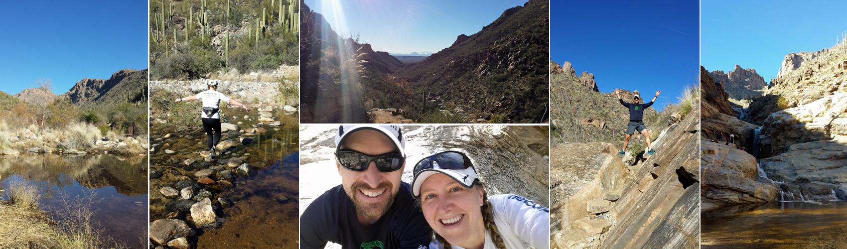
Water, water everywhere and not a drop to drink. Scenes from our trail run to Seven Falls inside Bear Canyon.
We’ve been in Tucson for just over a month now, and with the last of our boxes unpacked and recycled, we’re settling in to the business of exploring our new town. One of the things we love is the easy access to trails in every direction. We live just a few miles from the entrance to the eastern section of Saguaro National Park, and it’s just about a 30-minute drive to the western section of the park and other national forest recreation areas to the north and south.
This past weekend, looking to shake out our heavy post-holiday legs and enjoy a spell of warmer-than-usual weekend weather, we drove up to the Sabino Canyon parking area in Coronado National Forest, on the north side of the city. We’d been to Sabino once before, in early November before we officially moved here, and we were eager to return and try another trail. But instead of heading back into Sabino Canyon, we set out from the visitor’s center on a trail leading east into neighboring Bear Canyon with a destination of Seven Falls. (more…)
Reptilian Initiation in Sabino Canyon
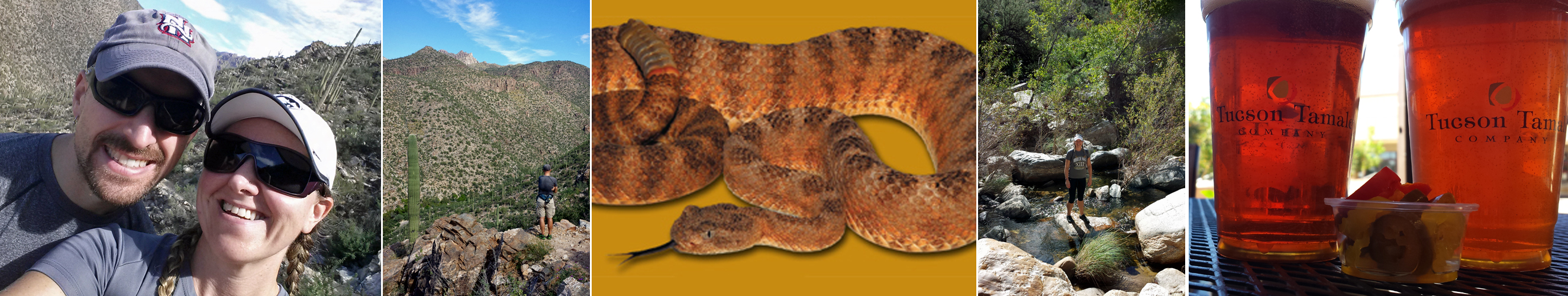
Exploring Sabino Canyon and all its friendly inhabitants back in November, a full day capped off with tamales and beer to celebrate not getting bitten by a rattlesnake. Snake photo from AZ Game and Fish Department website; we didn’t stick around long enough to take one of our own.
Everyone we’ve encountered in Tucson has mentioned Sabino Canyon as a “must go” destination. By everyone, I mean our realtor, bartenders, hair stylists, neighbors, coworkers and pretty much anyone else who learns we just moved here. So on our first plan-free Saturday in town, back in November while I was visiting for the weekend, we headed up to Sabino Canyon to check it out for ourselves. (more…)
We’re Off on the Road to Achill Island
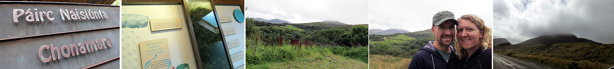
Scenes from our stop at Connemara National Park
We left Clifden Thursday morning with our sights set on tiny Achill Island on Ireland’s west coast. It was slated as a short drive (less than two hours), but we planned to take our time. Our first stop—just twenty minutes or so from the inn—was at Connemara National Park. On any other day, we would have trekked to the top of the park’s famous (and fog-covered) Diamond Hill. But two days before a marathon is not the time to take on an unknown hike (any hike, really). (more…)
The Rest of Jasper: Athabasca, Icefields, and Wilcox
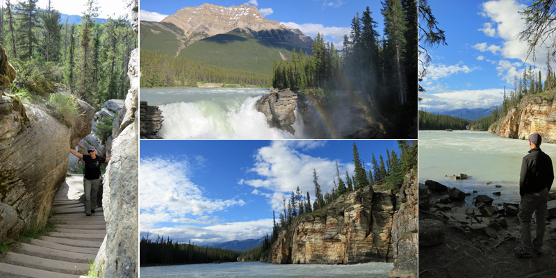
Scenes from the Athabasca River at Athabasca Falls, both above and below the 23-meter drop. While not exceptionally tall, the falls are some of the most powerful in the mountains due to the size of the river compared to the narrow canyon through which it flows.
Our visit to Jasper was the perfect start to our time in the Canadian Rockies. Jasper is a mellow little mountain town that quickly became one of the highlights of the trip. We weren’t thrilled to be leaving after just three days, but we were excited about what lay ahead: the Icefields Parkway and quaint towns within Banff National Park (Lake Louise, Banff, and Canmore). (more…)
Jasper National Park (Put It On Your Bucket List)
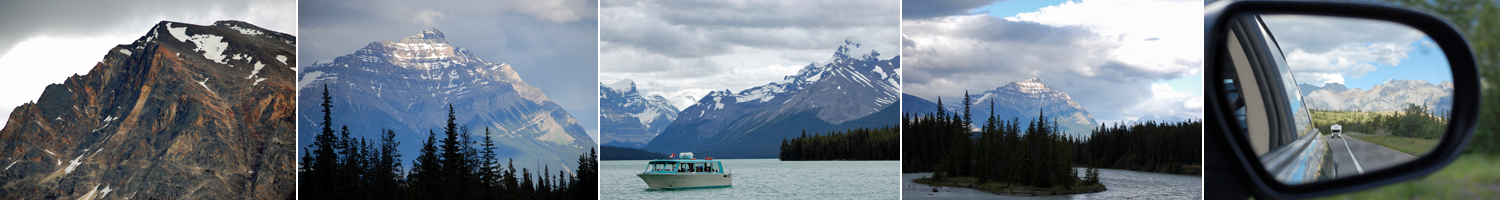
Get your camera! (L to R): Random mountains at sunset and sunrise; scenic Lake Maligne; amazing scenery in every direction.
Greetings from Jasper National Park in Alberta, Canada…our first official national park of this trip! Jasper is the farthest northwest that we will venture this summer, and it is absolutely worth the 3,000+ miles we trekked across the continent to get here. Jasper is the largest of Canada’s Rocky Mountains parks, and it’s also less trafficked than Banff and Yoho to the south. We try to avoid clichés and hyperbole here on WPG, but truth is, since we arrived in Jasper, there has been a stunning, mind-blowing, awe-inspiring, picturesque cliché around every corner.
We’ve been here for less than 24 hours, but it feels more like a week. We’ve visited the Miette Hot Springs, sampled local brews, stayed overnight in a rustic wilderness hostel (no running water), ran four miles around town this morning (nearly running into an elk), and hiked a bit at Lake Maligne. We are now back in town jumping on the grid for a few minutes before returning to the hostel (with a planned visit to Athabasca Falls on the way). (more…)
“…While We’re Fit Enough to Enjoy It”

L to R: Exploring the forts of Old San Juan, putting on a clinic in the ship’s bowling alley, hiking in the USVI National Park, and killing it with hover lunges and rows in TRX class.
We’ve talked about this time in our lives as one of self-assigned creative sabbatical. We’ve also referred to this year as one borrowed from retirement to travel while we are young enough—and fit enough and healthy enough—to enjoy it. This concept was evident during the last two weeks as we ventured to the Caribbean for a little pre-winter island hopping. I’ll share the how and the why behind the trip, along with other random musings, over the next few days. In the meantime, I’ve been meditating a bit on how the “fit enough” concept contributed to some of my best experiences on the cruise.
We knew we’d be consuming a little (okay, a lot…) more food and drink than we normally do, so we agreed in advance that we’d workout every day to keep any vacation weight gain in check. Admittedly, daily workouts aren’t much different from our routine at home, but it was important to remind ourselves of our priorities and to keep our ongoing fitness goals in the front of our minds even as we sailed south in search of rum and reggae. (more…)
It’s a Marathon, not a Sprint

My training locations so far. Week 1–Hiking the Whites. Week 2–Running along the Atlantic.
Since we’ve started our travel blog, a pattern has emerged with the timing of our posts: First, we hit the road, blogging three to five times per week about our trips. Then, after a few weeks on the road, we return to New England and go quiet for a while. Our silence is usually because our time in New England is filled with chores, errands, and visits with family and friends. It’s not all fun and games, though…someone has to wash my stinky running gear!
We followed this same pattern after returning from our last trip to Virginia and Tennessee. Now that we’ve been back in New England for a couple of weeks, it seemed about time to get back on the wagon and get some new posts published. Of course, we leave for Europe next week, which should make for much more interesting posts than picking up dry cleaning, going to the bank and organizing our gear in storage. Stay tuned!
For now, I wanted to put a little context around an activity that will color all of our upcoming travel for the next few months. Running! I know…I know…how is this different than any other trip? Well, it’s time for marathon training! It’s almost the end of Week 2 of my 18 week training plan for the Mount Desert Island (MDI) Marathon in Maine. The marathon is Sunday, October 14th, just a couple of days after my birthday, and we’ll be spending the weekend in Bar Harbor for the event.
The race is an important milestone for me, since it will be my first marathon since I started running in late 2009. In addition, it takes place in a location that is very important for J and me. We got married on Mount Desert Island in Northeast Harbor in 2011, and (as you may know from some of our prior posts) we returned to the area this year to celebrate our first anniversary. Not only is MDI beautiful, but it carries a huge amount of sentimental value.
Anyone who has run a long race or marathon before knows that you don’t just show up to compete. You have to train. And anyone who knows me knows that I like to train hard. It’s rare for a race to go by where I haven’t set and trained for an aggressive time goal (aggressive for me anyway), and the MDI marathon is no different. I’m pushing to finish the race in under 4 hours, with a target pace of 8:30 to 8:45 per mile. I’ve run faster than this in prior races, but never anything longer than a half marathon. Also, in addition to being voted the most scenic marathon in America and runner-up for best overall marathon, the MDI marathon is hilly. One blogger who ran the race reported his GPS watch showing 1,700 feet in elevation gain over the 26.2 miles and just as much in elevation loss.
I’m loosely following a Hal Higdon training plan. Higdon is a widely respected runner and author who has been helping runners succeed longer than I’ve been alive. I chose his Novice 2 plan, since it is a little more aggressive than Novice 1. I’ve not run a marathon before, so I stayed away from the intermediate training plans. In a nutshell, the plan increases your training mileage and the length of your longest weekly run week-over-week for 18 weeks leading into the race. There are some lower mileage weeks built into the plan for recovery after the longest of the training runs, and a taper period (period of rest and recovery) for the two to three weeks leading into the race. The plan also designates the pace of each run, with several runs being completed at the desired marathon race pace (“at pace”). The longest training run on the plan is 20 miles, and for me it will take place in late September about three weeks before race day.
So far, my adherence to the structure of the training plan has been less than perfect. I have gotten in all of my training, but it has required some substitutions and schedule changes due to travel and other activities. Here’s how Weeks 1 and 2 have gone so far, with the yellow representing what’s left this week:

I moved my long run up this week because we’re running a 5K race on Saturday (part of our goal of running a race per month in 2012). I also substituted some hikes for runs in Week 1 because we were in the White Mountains and the weather was fantastic. I was comfortable with these adjustments in the early weeks of the plan, since the mileage is in my comfort zone of 15 to 25 miles per week. As the plan continues, I need to buckle down. Given the demands of the plan, I don’t want to risk injury due to over-training . Also, since the plan is designed to provide enough rest leading into the longest run of the week and enough recovery after, it’s important that I stick to the prescribed schedule to avoid getting hurt or falling short on the important long training runs.
This will make for some scenic, interesting and challenging runs in upcoming Weeks 3 and 4, since I’ll be traveling in Germany and the Czech Republic! We will be visiting with family and friends for my cousin’s wedding before taking the train to Berlin, Leipzig, Dresden and Prague. I’m looking forward to seeing more of Europe, practicing my less-than-stellar German and, of course, logging some international marathon training miles! – M
Disconnecting for a Few Days…
We’re going off the grid for a few days, camping and hiking in the woods of Acadia. We will update our Twitter feed (which you can see on the right side of this site) when we can, but we probably won’t do a long post again until this weekend when we roll back into New Hampshire for our friends’ wedding. Hope you all have a great week!
Don’t Look Down!

Insane cliff faces, rocky trails, and stunning vistas were the stars of today’s adventure
I’ve never been fond of heights. I remember refusing to sit anywhere but on the floor in the middle of our Ferris Wheel car in Niagara Falls at a young age. In 8th grade, I practically had a nervous breakdown on our class rock climbing trip when I stood roped and harnessed at the top of a 150-foot cliff and had to lean backwards over the edge to rappel down.
In my adult life, not much has changed between me and heights. When J and I rode the Ferris Wheel in Paris last summer, I was nervous (although I did sit in my assigned seat for the entire ride). When we stood at the top of the aptly named “Jump Off” in The Smokies two months ago, I couldn’t wait to continue our hike a bit further from the edge. Today, I pushed the limits of my fears and tackled some challenging trails in Acadia National Park.
The park has two “hiking” trails that are often referred to as “technical rock climbing without the ropes.” These trails are The Precipice (a 0.9 mile trail that basically scales the side of an 930-foot cliff) and The Beehive (a slightly smaller cliff at 0.6 miles and 520 feet). This time of year The Precipice is closed due to peregrine falcon nesting season (sweet!), but The Beehive is open. J was excited for the hike, and after watching several YouTube videos and online reviews (that didn’t help much), I reluctantly agreed to make the trip.
While we lingered over coffee at the B&B this morning, we looked at our pocket hiking guidebook (purchased for a mere $3.50 at our local coffee/used bookstore, Crackskulls) and planned a hike that would bring us up The Beehive, across two miles of ridgeline to the summit of Champlain Mountain, and down over Huguenot Head on a trail made up of nearly 1,500 pink granite steps (interpret that last word loosely…). At the bottom, we would trot a short three miles along the Park Loop Road to get back to our car. It all sounded amazing, but I needed to get past The Beehive to enjoy the rest.
“Just keep going and don’t look down,” was my mantra for the first hour of the day. Even near the bottom of The Beehive, we had to use iron rungs secured into the rocks to get from one ledge of the trail to the next. A little further up, we resorted to crawling over a series of iron bars laid out like a ladder across a 20-foot drop. The two most difficult spots included a double series of iron bars that brought us almost straight up a rocky patch about 300 feet into the climb and a corner that required the use of one iron rung to scoot around it while stepping over a gap in the cliff’s edge.
Despite feeling weak in the knees, we made it to the top along with several other climbers, including a group from Dallas on their second-ever hike. (Their first was Mt. Dorr…yesterday.) It’s true that many people journey up The Beehive each year without issue, but before we started out, I wasn’t sure that would be the case for us. By the end of the day, we not only conquered The Beehive (and my fear of heights), but we enjoyed the open ridgeline walk and 360-degree views of the Atlantic, Mt. Desert Island and downtown Bar Harbor from the summit of Champlain Mountain. It was totally worth the terror. -M
Virtual Views of the Great Smokies
These first two weeks on the road were intended, in part, to be a dry run for our longer journey this summer. A short trip provided us with a chance to figure out what worked, what didn’t, and what we would do differently (or the same) when we’re gone for a longer period of time. One of the things we’re experimenting with is our use of technology on the road–things like which blogging platforms, internet connections, laptops, phones, and cameras work best for us. Included in the camera category is video…whether shooting video of our travels is feasible, and more importantly, whether it is interesting–both to us and to you.
For this trip, we used the basic movie setting on a non-HD, point-and-shoot camera. The plan was to include videos as part of our daily blog posts, but we found that our internet connections on the road (which were inconsistent at best, even with a mobile hotspot…) rarely provided the bandwidth we needed to upload them. We muscled our way through two painfully slow coffee shop uploads before waiting until we returned home to upload the rest. We’re rethinking our strategy for the next trip, but while we do that, you might be interested in this virtual hiking tour of the Great Smoky Mountain N.P…
To Hike or Not To Hike: Thru-Hiking the Appalachian Trail
“The mountains are calling and I must go.” –John Muir

Hiking the AT (L to R): Atop Charlie's Bunion--Directional signage--2,000 miles to Maine!--Icewater Springs shelter
More than once, the idea of thru-hiking the Appalachian Trail (hiking it from end to end) has crossed my mind. Three or four months of solitude in the woods didn’t sound so bad, hiking beautiful mountains and clearing my head while I explored the world on my own two feet. We’ve hiked short stretches of the AT in several states, including the Jackson-Webster loop in New Hampshire, and on this trip so far, our 10+ miles in Tennessee and Virginia. While I’ve enjoyed each of those day hikes, with every mile I log, I wonder if I’m really up for 2,000 more. And then we chatted with a few guys who were in the early stages of their thru-hike attempts, and I wondered why I ever entertained the idea in the first place.
The majority of thru-hikers tackles the trail in a northbound fashion, meaning they start their trek at Springer Mountain, Georgia and walk in a general northeasterly direction until—approximately 2,180 miles later—they reach the end of the trail on the summit of Mt. Katahdin in northern Maine. The journey takes the average hiker four to six months, although some take three and others take more. The trip is generally constrained by weather, since most hikers need to make it to Maine before it gets snowed in. In a less popular route, some hikers start at Katahdin in May or June and finish in Georgia in autumn.
The Park Service strictly regulates thru-hikers and backcountry camping. To minimize impact on the trails and ensure a level of traceability, hikers are required to stay overnight in designated shelters. There is a network of shelters (maintained by the Appalachian Mountain Club and other organizations) that offer protected lodging and are spaced roughly a day apart on the trail. Backcountry tenting is prohibited, and ridge runners (volunteers who run back and forth across segments of the trail) patrol the ridge to enforce that rule.
The shelters are beautiful buildings, often made of stone and timber. But what they offer in beauty, they lack in comfort. At the Icewater Springs shelter we checked out, the bunks consist of two large wooden platforms, one about two feet above the other. Hikers (mostly thru-hikers, with a few day hikers thrown in for good measure) sleep shoulder to shoulder, often with strangers, in the three-sided structure.
We encountered several thru-hikers on the trail yesterday. Most were men, hiking alone, ages ranging from early 20s to mid-60s. We saw only one couple and one solo woman, likely in her 40s. As a general rule, they were a chatty bunch, not afraid to strike up a conversation or ask a question. We heard tales “vermin” in the shelters and of guys like “Machete Mitch,” a survivalist type who is hiking parallel to the AT (but not on it) equipped with only a machete, a compass, and an iPad. (Apparently survivalist does not mean electronics minimalist.)
The “vermin” didn’t sound too exotic…mostly field mice and chipmunks looking for food…but in my mind, even a chipmunk becomes terrifying if he’s running across my face in the middle of the night. Then there’s the incessant snoring from your neighbor, and if you’re extra lucky, a crying baby like one hiker reported from a shelter in the night before. (Parents: I understand the desire to take your kids into the backcountry overnight, but can we agree to wait until they are potty-trained?)
And while the majority of the AT does cross scenic ranges in sparsely traveled places like those I imagined, some sections cross right through major tourist areas or the centers of towns. One hiker shared the culture shock he experienced when he hitched a ride into Gatlinburg after two weeks on the trail…and was dropped off near a Hard Rock Café. Not exactly the scenery of Muir.
I have total respect for folks that attempt a thru-hike, tackling a strenuous journey and relying only on themselves while they attempt the adventure of a lifetime. Most sources estimate only 1 in 4 hikers who start the hike will finish it. I, however, have a 0% chance of finishing it, because I will never start it. But I will go to the mountains when they call, and I will return to the AT. I’ll just continue to seek out my adventures in metered doses, in 10-mile sections that can be covered in one day. -J
Some Drives Are Better Than Others
Skyline Drive traverses the Blue Ridge Mountains through Shenandoah National Park. The north end of the drive begins in Front Royal, VA, a surprising town that appears to be maintaining itself quite well despite the economy. The architecture in Front Royal is familiar, each building crafted of the same stones, bricks and shingles of eastern towns ranging from Plattsburgh, NY to New Castle, PA to Greenville, SC. It is the architecture of hardware stores and insurance agencies, small public libraries and aging churches. We agreed Front Royal would go on the list of potential places to live “someday.”
At the entrance to Skyline Drive, Howard, the friendly, nervous, red-headed (and bearded) ranger, sold us our $80 Interagency Annual Pass, allowing access to the many places we hope to visit across the country in the next twelve months. Armed with our pass and some park literature, we hit the road. Skyline Drive is 105 miles of winding, rising and falling road filled with wildlife, old growth forest and very few other people. (Most park facilities don’t officially open for the season until later this spring.) After getting distracted by a handful of deer, two overlooks and countless circling hawks, it had taken us nearly 20 minutes to go the first five miles. It was looking like the drive would take longer than the three hours we had estimated. (The maximum speed limit on the drive is 35 MPH.) We were all smiles and in no hurry. Today, the deer posed for pictures, but despite our vigilance, the bears were elusive. Maybe we’ll be luckier in the Smokies…preferably from the car.

Today's Adventures (L to R): Wildlife-Scenery-North Entrance-The Appalachian Trail-Stony Man
At the halfway point of the drive, we parked and hit the trail for a short hike to the outlook on Stony Man Trail, recommended by the ranger as a brief but rewarding trip into the woods. At 4,010 feet, it is the second highest point in the park, and part of the summit route overlaps the Appalachian Trail. The trail was well-maintained, and we cruised to the top in 20 minutes. Once there, we surveyed the valley and took in a recommendation from a local couple to visit the “Camp David of President Herbert Hoover,” also in the park. We determined that this newly found part of America was worth a second visit and a much more thorough exploration of Shenandoah National Park. Perhaps later this spring…
The second half of the drive went more quickly than the first. At the end of the road, we opted to take the highway to Tennessee instead of the Blue Ridge Parkway. Although the Parkway is on our “must do someday” list, it wasn’t on our “must do this trip” list. We capped off our 415-mile day with a dip in the hotel pool and a tall draft beer. My first time in Tennessee has been more relaxing than expected. I’ll be enjoying the hotel bed tonight, since tomorrow night will bring the Great Smoky Mountains and our first campsite of the trip! –M
Here’s a look at what we saw from the summit of Stony Man:
